Category: NASA

Global Re-Analysis of Vegetation

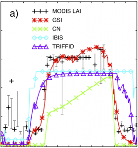
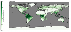
Our previous work on the remote-sensing based data assimilation framework has been extended to regional and global scales. It employs a subgrid‐scale representation of plant functional types (PFTs) and elevation classes to generate a globally applicable phenological parameter set. We are able to predict (or hindcast) a 50 year long (1960–2009) daily 1° × 1° global phenology climate …

Continue reading

Remote Sensing Data Assimilation

We have developed a computational framework for data assimilation of Fraction of Photosynthetically Active Radiation absorbed by vegetation (FPAR) and Leaf Area Index (LAI) from the MODerate Resolution Imaging Spectroradiometer (MODIS) to constrain empirical temperature, light, moisture and structural vegetation parameters in a prognostic phenology model.   It uses the Ensemble Kalman Filter (EnKF) after …

Continue reading

Blue Marble images on the IPCC 4th assessment report (2007)

The Blue Marble western and eastern hemispheres by Reto Stöckli (NASA Earth Observatory) are displayed to the left as printed on the front cover of the IPCC (Intergovernmental Panel on Climate Change) 4th assessment WGI report “The Physical Science Basis”.   These images integrate land, ocean, sea ice and clouds into a visual representation of …

Continue reading

The European Heat wave of 2003 as seen from MODIS

Europe was experiencing a historic heat wave during the summer 2003. Compared to the long term climatological mean, temperatures in July 2003 were sizzling. Figure 1 below shows the differences in day time land surface temperatures of 2003 to the ones collected in 2000, 2001, 2002 and 2004 by the Moderate Resolution Imaging Spectroradiometer (MODIS) …

Continue reading

Terra satellite launch & deploy (Remake from 2006)

For Terra’s 5th anniversary I have created a remake of the original launch & deploy 3D animation:

Blue Marble Next Generation

The Blue Marble Next Generation (BMNG, 2005) is a cloud-free global satellite data set offering great spatial detail. It spans a longer data collection period than the original Blue Marble from 2000 and 2002. The original Blue Marble was a composite of four months of MODIS observations with a spatial resolution (level of detail) of …

Continue reading

Blue Marble Next Generation Monthly Composites

A monthly collection of earth close-up images Click on the respectiv images to get larger versions. January 2004 Kenya February 2004 Lake Etosha March 2004 Sahara Desert April 2004 The Alps May 2004 The Himalayas June 2004 The Andes July 2004 Salt Lake City August 2004 Eastern Greenland September 2004 Patagonia October 2004 The Okawango Delta November 2004 Indonesian Islands December 2004 The Bahamas

Aura satellite launch & deploy

Aura is a earth observing satellite and it is part of NASA Earth Observing System (EOS). Aura’s four instruments study the atmosphere’s chemistry and dynamics. Aura’s measurements will enable us to investigate questions about ozone trends, air quality changes and their linkage to climate change. Aura’s measurements will provide accurate data for predictive models and …

Continue reading

Aqua satellite launch & deploy

Aqua, Latin for water, is a NASA Earth Science satellite mission named for the large amount of information that the mission is collecting about the Earth’s water cycle, including evaporation from the oceans, water vapor in the atmosphere, clouds, precipitation, soil moisture, sea ice, land ice, and snow cover on the land and ice. Additional …

Continue reading

MODIS Satellite versus GOCART Model Aerosol Animation