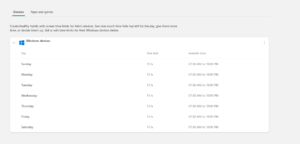
Category: General

How to “bluemarbelize” Google Maps?

Introduction Google Maps and Google Earth (hereafter Google Maps) are publicly available tools useful to visually explore the geography of our planet. Globally distributed high resolution satellite data are used as a background to dynamically map physical, geographical, historical, socio-economic or political thematic layers. Nowadays the average, educated person with access to the internet either …

Continue reading

Land use change in Sumatra

The Swiss NGO Paneco is engaged in Sumatra (Indonesia) where anthropogenic land use changes threaten local fauna and flora. The collaboration with Paneco has started with a small project that aimed at diagnosing rainfall intensity of a storm from TRMM 3B42 space radar data due to a lack of locally available rain gauges. The project …

Continue reading