By analysis of our MeteoSwiss high quality satellite-based solar irradiance maps created by the Heliomont algorithm I’ve found that the sunniest place in Switzerland is close to the Monte Rosa hut of the Swiss Alpine Club SAC. During the calculation of the Solar Atlas of Switzerland (to be published as “The Solar Cadaster of Switzerland” on the Geoportal of the Swiss Government) I have also detected the absolutely DARKEST spot in Switzerland. Here it is:
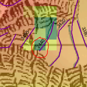
The point lies at 636125 / 93050 (CH1903 / LV03 coordinate system) at the border between Switzerland and Italy. It has as sky view factor of 0.003. This is about the same sky view as found in a bottomless pit. There is no solar irradiance getting down there. The yearly mean solar irradiance is around 0.5 W m-2 (Watts per square meter; the average over most of Switzerland is well over 150 W m-2). The reason for this low predicted solar irradiance can be found in the Swiss elevation model DHM 25 at the spatial resolution of 25 m. These are the topographic elevations (m) of the darkest point including its 8 neighboring points:
2996 2622 3414
2763 2440 3457
3070 3131 3484
The center point lies between 200 – 1000 m lower than the surrounding grid points. Is this bottomless pit in beautiful landscape reality or a digital artifact?
Update
The customer service of SwissTopo has kindly provided a credible answer: The darkest spot is indeed an artifact of the DHM25 dataset due to a contour line which was digitized 1000 m below its actual elevation: