Most commented posts
- Boeing 737-800 Home Cockpit (Linux-based, notably …) — 7 comments
- Boeing 737 Control Columns — 2 comments
- Buttkicker (Füdligingger) under the seat — 2 comments
- Fitting the MIP to the real Cockpit — 1 comment

Mar 15 2012
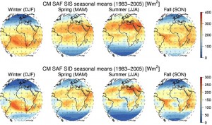
We have processed a global irradiance and direct irradiance climate data record from the Meteosat first generation satellites (Meteosats 2 to 7, 1983–2005). The CDRs are available free of charge for all purposes from the EUMETSAT‘s Satellite Application Facility on Climate Monitoring Web User Interface at monthly, daily and hourly means at a spatial resolution …
Mar 09 2012
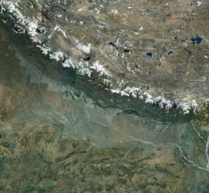
Introduction Google Maps and Google Earth (hereafter Google Maps) are publicly available tools useful to visually explore the geography of our planet. Globally distributed high resolution satellite data are used as a background to dynamically map physical, geographical, historical, socio-economic or political thematic layers. Nowadays the average, educated person with access to the internet either …
Feb 24 2012
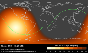
I am working on a solar position and orbit predictor application for the International Space Station that will serve as planning tool for a new art project of Christian Waldvogel. For updates visit his website http://www.waldvogel.com
Jan 01 2012
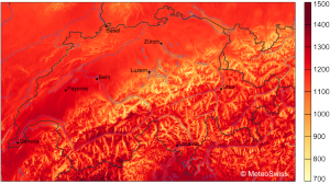
My tasks at MeteoSwiss include the analyses of the spatial and temporal variability of the surface solar irradiance with special emphasis on the complex Alpine terrain and the diverse interactions of horizon, snow cover and cloudiness in this terrain. One major result of this work is a satellite-based climatology of solar irradiance including its radiation …
Aug 25 2011
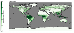
Our previous work on the remote-sensing based data assimilation framework has been extended to regional and global scales. It employs a subgrid‐scale representation of plant functional types (PFTs) and elevation classes to generate a globally applicable phenological parameter set. We are able to predict (or hindcast) a 50 year long (1960–2009) daily 1° × 1° global phenology climate …
Nov 26 2008
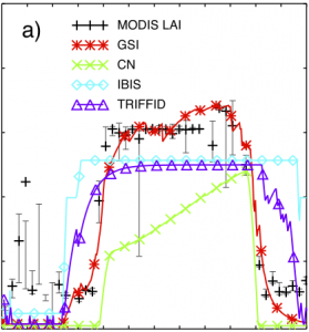
We have developed a computational framework for data assimilation of Fraction of Photosynthetically Active Radiation absorbed by vegetation (FPAR) and Leaf Area Index (LAI) from the MODerate Resolution Imaging Spectroradiometer (MODIS) to constrain empirical temperature, light, moisture and structural vegetation parameters in a prognostic phenology model. It uses the Ensemble Kalman Filter (EnKF) after …
Jan 01 2007
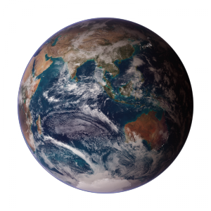
The Blue Marble western and eastern hemispheres by Reto Stöckli (NASA Earth Observatory) are displayed to the left as printed on the front cover of the IPCC (Intergovernmental Panel on Climate Change) 4th assessment WGI report “The Physical Science Basis”. These images integrate land, ocean, sea ice and clouds into a visual representation of …
Nov 27 2006
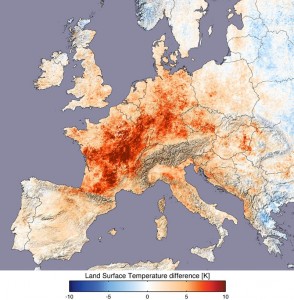
Europe was experiencing a historic heat wave during the summer 2003. Compared to the long term climatological mean, temperatures in July 2003 were sizzling. Figure 1 below shows the differences in day time land surface temperatures of 2003 to the ones collected in 2000, 2001, 2002 and 2004 by the Moderate Resolution Imaging Spectroradiometer (MODIS) …
Jan 01 2006
For Terra’s 5th anniversary I have created a remake of the original launch & deploy 3D animation:
Dec 23 2005
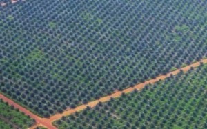
The Swiss NGO Paneco is engaged in Sumatra (Indonesia) where anthropogenic land use changes threaten local fauna and flora. The collaboration with Paneco has started with a small project that aimed at diagnosing rainfall intensity of a storm from TRMM 3B42 space radar data due to a lack of locally available rain gauges. The project …